◉ California Highway 1 & Big Sur Coast · iPhone & CarPlay
California’s Big Sur coast, curated for the open road.
Big Sur is the stretch of California's Highway 1 coast between Carmel and San Simeon, about 90 miles of cliffs, turnouts, and bridges. Winding between dramatic Santa Lucia cliffs and crashing Pacific surf, California’s Highway 1 is America’s premier coastal road trip. WanderWay alerts you to hidden ocean turnouts, ancient redwood groves, and historic coastal bridges with directional spoken audio, and lets you download place information before you lose signal.
Free to try · One-time purchase · Zero subscriptions · Zero ads · No tracking
By Derek Boyer, WanderWay's founder & developer · Published · Updated
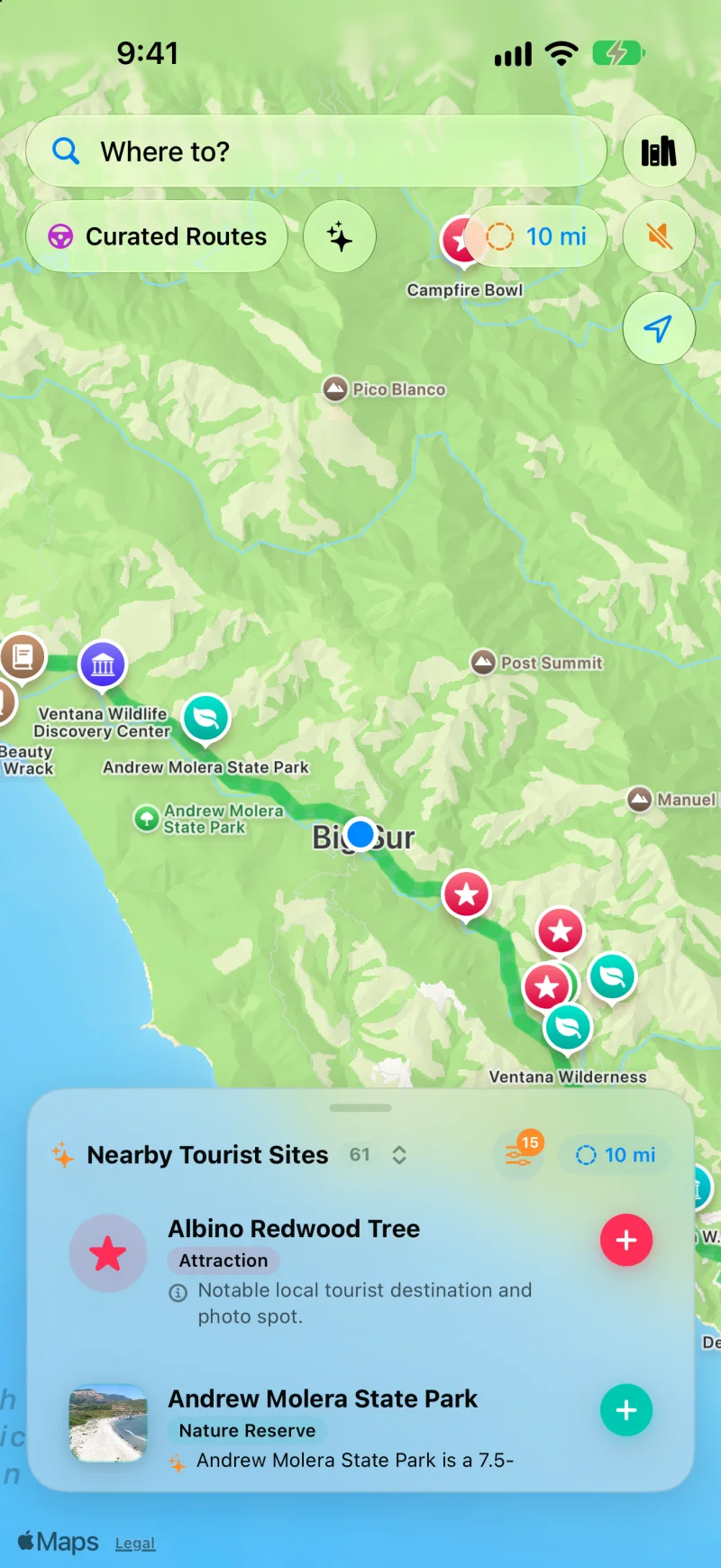
60 coastal sights along Highway 1. Discover Andrew Molera State Park, rare albino redwood trees, beach trailheads, and panoramic ocean viewpoints.
Pacific Coast Touring
Engineered for coastal twists & little to no cell service.
Highway 1 demands undivided attention on the road. WanderWay speaks the landscape so you never need to touch your screen.
01 / DOWNLOAD BEFORE YOU GO
Built for Big Sur’s Dead Zones
There is little to no cell service along most of the coast between Carmel and San Simeon. Download the places along your coastal route before setting out, so their descriptions and narration stay on your iPhone. Maps and routing may still need a connection, so set up your route in town.
02 / DIRECTIONAL OCEAN ALERTS
Advance Warning for Safe Turnouts
Cliffside turnouts appear quickly on Highway 1's tight switchbacks. WanderWay gives advance spoken notice ("Ahead on your right: Ocean Viewpoint") giving you time to brake and pull over safely.
03 / NATURE & REDWOOD FILTERS
Ancient Groves & Marine Sanctuaries
Filter exclusively for Nature Reserves to discover old-growth redwood canyons, marine reserves, sea otter lookouts, and hidden state park trailheads tucked off the asphalt.
04 / CARPLAY DASHBOARD
Native Cockpit Exploration
Connect to Apple CarPlay for a high-visibility map designed for the sunlight of the Pacific coast. See upcoming turnouts and points of interest right on your vehicle's console.
Know Before You Go
How long is the drive through Big Sur?
The Big Sur Coast Highway, which the federal America's Byways program lists as an All-American Road, runs about 72 miles from Malpaso Creek near Carmel Highlands to San Carpóforo Creek in San Luis Obispo County. The byway listing allows 1.5 hours to drive it and five hours to experience it. Counted from the town of Carmel to San Simeon, the Big Sur coast is about 90 miles long.
BIXBY BRIDGE
An open-spandrel arch from 1932.
Thirteen miles south of Carmel, Bixby Creek Bridge is a 714-foot reinforced-concrete arch about 260 feet above the creek below. It was one of the tallest single-span arch bridges in the world when it opened, and it is one of the most photographed bridges in California.
MCWAY FALLS
An 80-foot waterfall onto the sand.
About 37 miles south of Carmel in Julia Pfeiffer Burns State Park, McWay Falls drops 80 feet from granite cliffs onto the beach below.
FUEL PLANNING
Gas is limited along the coast.
The Big Sur Chamber of Commerce lists gas stations as a public service because gas is limited in Big Sur. Fill up in Carmel or Monterey heading south, or in Cambria heading north, before committing to the drive.
WITH WANDERWAY
Sixty stops, downloaded before the signal fades.
Switch on Nature Reserves or Scenic Overlooks in the Nearby panel to surface more than 60 mapped stops along the corridor, hear a directional heads-up before each turnout ("Ahead on your right...") and download the whole stretch before you lose cell signal south of Carmel Highlands.
Plan Around Closures
Why does Highway 1 keep closing?
Highway 1 through Big Sur is cut into steep, slide-prone coastline, and heavy winter rain regularly takes a bite out of it. The road has closed for months at a time several times in the last decade.
After one of the most severe winters on record, 2017 brought the worst damage: flooding undermined Pfeiffer Canyon Bridge, which had to be demolished, and its replacement did not open until October 2017. In May, the Mud Creek slide, the largest known landslide on the Big Sur coast, buried a quarter mile of highway under more than 6 million cubic yards of material; Caltrans rebuilt the road across it and reopened it in July 2018. In January 2021, a mudslide at Rat Creek washed out 150 feet of roadway. Paul's Slide closed the highway from January 2023 to June 2024, and Regent's Slide, which hit in February 2024, kept it closed until January 14, 2026, when through travel between Carmel and Cambria resumed for the first time in almost three years.
Open Curated Routes, pick a loop or a drive to a destination, and choose how long you have, from 30 minutes to 5 hours. Turn on Prefer Scenic Backroads to stay off highways, or Favor US scenic byways to lean on designated byways. To make a planned trip more scenic, use the Faster or Prettier slider on the route card. Scenic adds up to a quarter more time for sights along the way and is free. Very scenic and Most scenic add more time and take backroads instead of highways; they’re part of WanderWay Unlock.
Will WanderWay work without cell signal in Big Sur?
Yes, if the route is saved first. With Saved When You Start, WanderWay downloads the route as you set off, so the sights and their descriptions stay with you when signal drops. On cellular data, it asks before downloading. Live traffic, weather, and park alerts still need a connection.
What should I know before relying on WanderWay in Big Sur?
Place details come from public sources such as Wikipedia, Wikimedia Commons, the National Register of Historic Places, and the National Park Service, so a small or newly reopened spot may be missing. Routing comes from Apple Maps, so check the park or state road agency before a long mountain or coastal drive. Watch the road, not the screen: stories are spoken so you can keep your eyes up.
Common questions about road tripping Big Sur and Highway 1 with WanderWay.
Does WanderWay work without cell signal in Big Sur? +
Yes. There is little to no cell service along most of the 90-mile Big Sur coast between Carmel and San Simeon. WanderWay lets you download the places and descriptions along your route before leaving town, so narration of those places can keep going without a signal. Maps and routing may still need a connection, so set up your route before you lose signal.
Does WanderWay announce ocean turnouts and coastal vista points? +
Yes. WanderWay directionally announces ocean turnouts and scenic viewpoints (e.g. 'Ahead on your right: Ocean View Turnout') giving you advance notice before steep cliffside approaches.
What stops does WanderWay reveal along Highway 1? +
WanderWay maps over 60 points of interest along the Big Sur corridor, including Andrew Molera State Park, Pfeiffer Big Sur, rare coastal redwoods, historic lighthouses, and hidden beach trails.
Drive Highway 1
Experience California’s Pacific Coast Highway with WanderWay.
Free to download with a free trial, then a one-time purchase. No ads, no subscriptions, and zero tracking. iPhone and Apple CarPlay on iOS 26 or later.