
One Tap Isolates Covered Bridges
Toggle the Covered Bridge filter to remove map clutter and instantly view every authentic Burr arch, Town lattice, and Queenpost truss within up to 40 miles.
Pennsylvania is home to over 200 historic timber covered bridges—more than any other state in the nation. WanderWay filters out the interstates, builds custom backroad loops through Lancaster County and the Lehigh Valley, and speaks the history of each span as you approach.
Free to try · One-time purchase · Zero subscriptions · Zero ads · No tracking
By Derek Boyer, WanderWay's founder & developer · Published · Updated
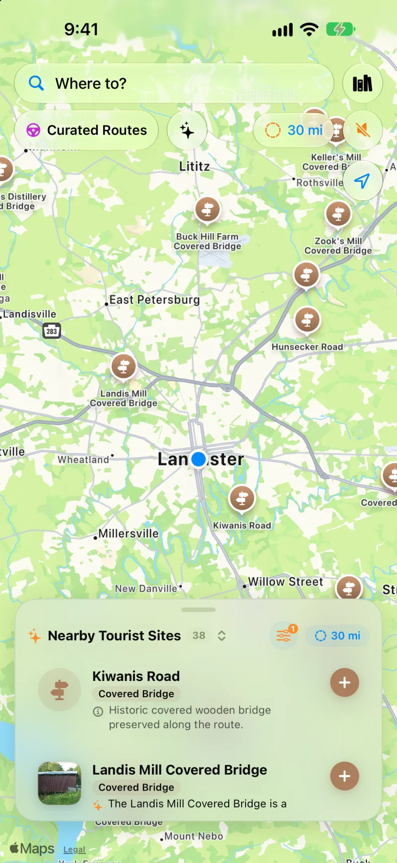
38 covered bridges within 30 miles of Lancaster, a radius that reaches past the county line into its neighbors. Tap any pin for construction dates, truss styles, and Wikipedia photos.
Touring Pennsylvania Heritage
Standard commuter navigation bypasses historic treasures. WanderWay puts them at the center of your weekend drive.
Toggle the Covered Bridge filter to remove map clutter and instantly view every authentic Burr arch, Town lattice, and Queenpost truss within up to 40 miles.
As you approach spans like Landis Mill, Hunsecker Road, or Keller's Mill, WanderWay speaks where they are relative to your car ("Ahead on your right...") without interrupting your music.
Don't spend hours stringing together GPS waypoints. Open Curated Routes, select 2 hours, toggle 'Prefer Scenic Backroads', and let WanderWay plan a loop connecting multiple bridges back to your start.
Plug into Apple CarPlay to see live bridge pins, upcoming turnouts, and historic summaries directly on your vehicle's dashboard screen.
Know Before You Go
More than any other state. The National Society for the Preservation of Covered Bridges counts 213, and the Theodore Burr Covered Bridge Society of Pennsylvania counts just under 210 authentic bridges, a fraction of the more than 1,500 the state once had.
Visit Lancaster PA counts 28 covered bridges still standing in Lancaster County, and the county government says that is more than any other Pennsylvania county. All but three (Hunsecker's Mill, Kurtz's Mill, and Willow Hill) are listed on the National Register of Historic Places.
Almost all of Lancaster County's bridges are Burr arch trusses (two long arches sandwiching a frame of upright posts), painted barn red with white portals. Statewide, 123 bridges use the Burr arch; the crisscross Town lattice, built from smaller lumber, survives in 20, twelve of them in Bucks County.
These aren't museum pieces: the county lists 20 of its bridges as still open to traffic. Most Pennsylvania covered bridges are only 12 to 15 feet wide inside, so expect one lane, posted weight limits on some spans, and a wait for oncoming traffic to clear.
WanderWay speaks up as you approach each bridge ("Ahead on your right...") and shows a live detour-time badge so you know the cost of the gravel turn before you take it — useful when a 30-mile radius search can turn up a dozen bridges at once.
Beyond Lancaster
Lancaster's 28 lead the state. Washington County is second with 23, and Columbia County has 19, or 25 counting neighboring Montour and the bridges on the Northumberland line. WanderWay's 40-mile search radius will often catch two or three counties' worth from a single parked car.
What survives is spread across the state, from Washington and Greene counties in the southwest, home to all ten of Pennsylvania's kingpost bridges, to the Burr arches of Lancaster and the Town lattice spans of Bucks County in the southeast. These are exactly the kind of backroads WanderWay's "Prefer Scenic Backroads" routing favors over the interstate.
Keep exploring: a national guide to covered bridge road trips, Vermont's Green Mountain covered bridges, and Ohio's covered bridge counties.
Open Curated Routes, pick a loop or a drive to a destination, and choose how long you have, from 30 minutes to 5 hours. Turn on Prefer Scenic Backroads to stay off highways, or Favor US scenic byways to lean on designated byways. To make a planned trip more scenic, use the Faster or Prettier slider on the route card. Scenic adds up to a quarter more time for sights along the way and is free. Very scenic and Most scenic add more time and take backroads instead of highways; they’re part of WanderWay Unlock.
Yes, if the route is saved first. With Saved When You Start, WanderWay downloads the route as you set off, so the sights and their descriptions stay with you when signal drops. On cellular data, it asks before downloading. Live traffic, weather, and park alerts still need a connection.
Place details come from public sources such as Wikipedia, Wikimedia Commons, the National Register of Historic Places, and the National Park Service, so a small or newly reopened spot may be missing. Routing comes from Apple Maps, so check the park or state road agency before a long mountain or coastal drive. Watch the road, not the screen: stories are spoken so you can keep your eyes up.
Pennsylvania FAQ
Everything you need to know about exploring Pennsylvania's historic bridges with WanderWay.
WanderWay connects directly to the National Register of Historic Places and OpenStreetMap, giving drivers instant access to Pennsylvania's 200+ surviving covered bridges, including the 28 covered bridges still standing in Lancaster County.
Yes. WanderWay's Curated Routes feature lets you pick your available drive time (e.g. 90 minutes or 2.5 hours), favor Covered Bridges, and generate a closed-loop backroad route that starts and finishes at your location.
Yes. WanderWay provides directional spoken audio (e.g., 'Ahead on your right: Landis Mill Covered Bridge') so you can keep your eyes on the winding country roads without needing to glance down at your phone.
Yes, for the places along your route. You can download the places and descriptions along your route before leaving home, so they stay on your iPhone even with spotty cellular service. Maps and routing may still need a connection, so set up your route before you lose signal.
Start your heritage drive
Free to download with a free trial, then a one-time purchase. No ads, no subscriptions, and zero tracking. iPhone and Apple CarPlay on iOS 26 or later.
The bridge counts and history on this page come from these pages: