
Ancient Mounds & Canal Heritage
Follow the historic Scioto corridor between Columbus, Circleville, Chillicothe, and Waverly. Discover UNESCO-inscribed Hopewell Ceremonial Earthworks, historic pioneer cemeteries, and canal locks.
Ohio scenic driving means the state's quieter routes: the Scioto Valley, the Appalachian foothills of southern Ohio, the Ohio River along Route 52, and its covered bridge counties. From the rolling Appalachian foothills and ancient Hopewell earthworks of the Scioto Valley to hidden timber bridges and serene state parks, Ohio is filled with stories waiting just off the highway. WanderWay narrates the landscape as you drive.
Free to try · One-time purchase · Zero subscriptions · Zero ads · No tracking
By Derek Boyer, WanderWay's founder & developer · Published · Updated
Handpicked Byway Corridors
Whether you have a free two-hour window or an entire Saturday, WanderWay turns Ohio's rural routes into immersive road trips.
Follow the historic Scioto corridor between Columbus, Circleville, Chillicothe, and Waverly. Discover UNESCO-inscribed Hopewell Ceremonial Earthworks, historic pioneer cemeteries, and canal locks.
Cruise the tree-lined ridges of southern Ohio, taking in scenic valley overlooks, 19th-century charcoal blast furnaces, and secluded sandstone gorges.
Tour authentic Burr arch and Smith truss covered bridges scattered across Fairfield, Preble, Ashtabula, and Vinton counties. Let WanderWay guide you down quiet country roads.
Follow Route 52 along the Ohio River, discovering historic riverfront landings, hillside vineyards, and panoramic lookouts overlooking Kentucky and West Virginia.
Know Before You Go
The Scioto Valley around Chillicothe holds five of the eight sites in the Hopewell Ceremonial Earthworks, Ohio's first UNESCO World Heritage Site. The Hopewell culture built these earthen walls and mounds 1,600 to 2,000 years ago to a standard unit of measure.
Hopewell Culture National Historical Park near Chillicothe manages five of the sites, including Mound City Group and Seip Earthworks. The Ohio History Connection manages the other three: the Octagon and Great Circle Earthworks in Newark, and Fort Ancient.
Ashtabula County, in Ohio's northeast corner, has 19 covered bridges, 17 of them open to traffic, and is considered the state's covered bridge capital. They include the nation's longest covered bridge (Smolen-Gulf, 613 feet) and what the county's visitors bureau calls America's shortest drive-through bridge (Liberty Street, 18 feet).
Pike and Ross counties follow the Scioto River valley, and Vinton County to the east still has the remains of the Hope, Richland, and Vinton charcoal iron furnaces from the mid-1800s — the kind of terrain that keeps a GPS routing you onto four-lane bypasses instead.
WanderWay's developer field-tests every release on these same roads, so the Scioto Valley's earthworks, covered bridges, and state parks are mapped in detail — toggle "Prefer Scenic Backroads" and WanderWay keeps you off Route 23's truck traffic.
Hocking Hills State Park, in southeastern Ohio, rounds out the region's natural side with deep, hemlock-shaded sandstone gorges. Ash Cave is the largest recess cave in Ohio, nearly 700 feet wide and 100 feet high, and Old Man's Cave and Cedar Falls each have a trail of about a mile. None of the three sit directly on Route 23, so a GPS tuned for the fastest route skips them entirely; WanderWay's Nature Preserves filter surfaces all three along with the quieter pull-offs around them.
Where It Started
WanderWay is built and field-tested around Waverly, in Pike County, Ohio — home to Pike Lake State Park, Lake White State Park, Pike State Forest, and the Piketon Mounds earthworks.
Keep exploring: the Pike County community page for local testing spots around Waverly and Piketon, and a national guide to covered bridge road trips for Ohio's timber-truss neighbors.
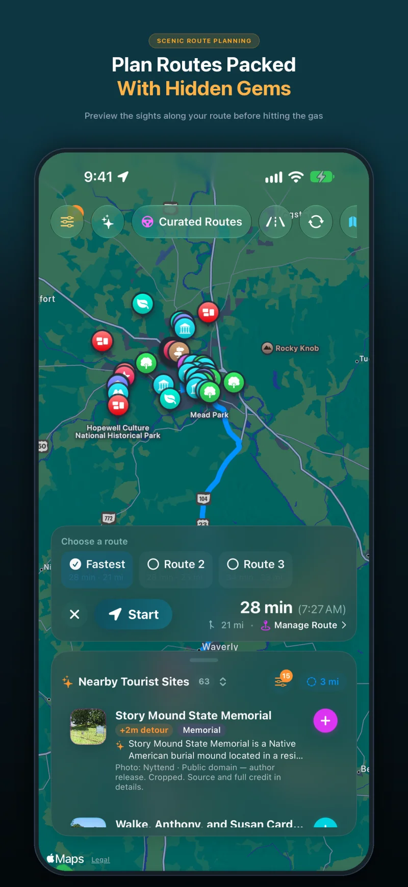
Select an afternoon duration and bypass highways for quiet Ohio county roads.
Open Curated Routes, pick a loop or a drive to a destination, and choose how long you have, from 30 minutes to 5 hours. Turn on Prefer Scenic Backroads to stay off highways, or Favor US scenic byways to lean on designated byways. To make a planned trip more scenic, use the Faster or Prettier slider on the route card. Scenic adds up to a quarter more time for sights along the way and is free. Very scenic and Most scenic add more time and take backroads instead of highways; they’re part of WanderWay Unlock.
Yes, if the route is saved first. With Saved When You Start, WanderWay downloads the route as you set off, so the sights and their descriptions stay with you when signal drops. On cellular data, it asks before downloading. Live traffic, weather, and park alerts still need a connection.
Place details come from public sources such as Wikipedia, Wikimedia Commons, the National Register of Historic Places, and the National Park Service, so a small or newly reopened spot may be missing. Routing comes from Apple Maps, so check the park or state road agency before a long mountain or coastal drive. Watch the road, not the screen: stories are spoken so you can keep your eyes up.
Local Driving FAQ
Common questions about exploring Ohio backroads with WanderWay.
WanderWay was built and field-tested in southern Ohio and the Appalachian foothills. It features deep regional coverage of Ohio's covered bridges, Hopewell ceremonial earthworks, state nature preserves, and historical markers, announcing them through spoken directional narration as you drive.
Yes. Open Curated Routes, choose your available time (e.g. 2 hours), toggle 'Prefer Scenic Backroads', and select priorities like Covered Bridges or Scenic Overlooks. WanderWay builds a circular route starting and finishing at your driveway that avoids multilane highways.
Yes, for the places along your route. You can download the places and descriptions along your route before heading into rural valleys like the Scioto River basin, Paint Creek, or Shawnee State Forest, so narration of those places keeps going without a signal. Maps and routing may still need a connection, so set up your route before you lose signal.
Ready to hit the road?
Free to download with a free trial, then a one-time purchase. No ads, no subscriptions, and zero tracking. iPhone and Apple CarPlay on iOS 26 or later.
The facts about Ohio's earthworks, bridges, and parks on this page come from these pages: