
Hear about bridges before you pass them.
You shouldn't have to glance at a screen while winding through creek valleys. WanderWay speaks the exact orientation and history as you approach: construction year, builder, and structural style.
A covered bridge is a timber bridge with a roof and siding that keep rain and snow off its wooden trusses, which is why many have lasted well over a century. Historic timber bridges are among America’s greatest roadside treasures, but they’re almost always tucked away on gravel roads, county byways, and river bends that highway GPS ignores. WanderWay brings them directly to your dashboard.
Free to try · One-time purchase · Zero subscriptions · Zero ads · No tracking
By Derek Boyer, WanderWay's founder & developer · Published · Updated
Engineered for bridge hunters
Whether you're cruising Ohio, Pennsylvania, Indiana, or New England, WanderWay is your specialized roadside guide.
You shouldn't have to glance at a screen while winding through creek valleys. WanderWay speaks the exact orientation and history as you approach: construction year, builder, and structural style.
Is that scenic timber bridge 2 minutes away or a 25-minute crawl? Live detour badges (+2m, +5m) calculate the exact round-trip detour penalty before you leave the pavement.
Open Curated Routes, set a duration (e.g. 2 hours), select Covered Bridges, and let WanderWay assemble a closed-circuit driving loop that visits multiple bridges and returns you home without repeating roads.
Streamlined Apple CarPlay interface keeps your cabin safe. Download place information for your route before entering steep hollows and dead zones.
Know Before You Go
Fewer than 900 historic covered bridges survive in the United States, according to the Federal Highway Administration's Covered Bridge Manual, out of a reported 14,000 at one time.
Theodore Burr's arch truss is the most common surviving design, with about 224 examples. Ithiel Town's lattice, patented in 1820 and built from smaller lumber that unskilled crews could frame, survives in about 135. The Howe truss, patented by William Howe in 1840 with iron rods for its upright members, survives in about 143.
Pennsylvania has the most covered bridges (213) and Ohio is second (148) in the National Society for the Preservation of Covered Bridges' count. Lancaster County, Pennsylvania has 28. Vermont has the most per square mile, and Ohio's Ashtabula County has the country's longest covered bridge (Smolen-Gulf, 613 feet) and what its visitors bureau calls America's shortest drive-through one (Liberty Street, 18 feet).
Covered bridges were built for horses and wagons, so plenty of surviving spans post weight limits or stay single-lane with a yield sign at one end. A handful are closed to vehicles entirely and cross on foot only — check the posted sign before you commit to the gravel.
Switch on Covered Bridges in the Nearby panel to see every mapped span within 40 miles of your car or a dropped pin, hear a directional heads-up as you approach ("Ahead on your right...") and check a live detour-time badge before you leave the highway.
Preservation
Arson has destroyed at least 148 covered bridges across the U.S. and Canada over the past five decades — about three a year — according to the National Society for the Preservation of Covered Bridges. Floods take their share too: Vermont's 1927 flood alone destroyed about 100 covered bridges.
Many survivors are listed on the National Register of Historic Places, but a listing doesn't stop a careless campfire or a flooded creek. Because many remaining bridges sit in hollows and creek valleys with limited cell service, WanderWay lets you download the places and descriptions along your route before you leave pavement, so narration of those places can keep going even where your phone has no signal.
Keep exploring: Pennsylvania's Lancaster County covered bridges, Vermont's Green Mountain covered bridges, and Ohio's covered bridge counties.
Inside the App
Select Covered Bridges in the Nearby panel to reveal historic timber crossings in your region with real-time driving distances and detour estimates.

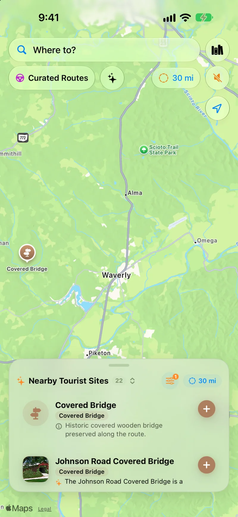
Open Curated Routes, pick a loop or a drive to a destination, and choose how long you have, from 30 minutes to 5 hours. Turn on Prefer Scenic Backroads to stay off highways, or Favor US scenic byways to lean on designated byways. To make a planned trip more scenic, use the Faster or Prettier slider on the route card. Scenic adds up to a quarter more time for sights along the way and is free. Very scenic and Most scenic add more time and take backroads instead of highways; they’re part of WanderWay Unlock.
Yes, if the route is saved first. With Saved When You Start, WanderWay downloads the route as you set off, so the sights and their descriptions stay with you when signal drops. On cellular data, it asks before downloading. Live traffic, weather, and park alerts still need a connection.
Place details come from public sources such as Wikipedia, Wikimedia Commons, the National Register of Historic Places, and the National Park Service, so a small or newly reopened spot may be missing. Routing comes from Apple Maps, so check the park or state road agency before a long mountain or coastal drive. Watch the road, not the screen: stories are spoken so you can keep your eyes up.
Common Questions
Have questions about planning a scenic bridge drive? Here is how WanderWay handles rural touring.
WanderWay includes a dedicated Covered Bridges category filter that scans up to 40 miles (or 60 km) around your vehicle or any dropped pin. When navigating, WanderWay monitors your heading and speaks directional announcements ("Ahead on your right, Johnson Road Covered Bridge") so you never miss a historic truss hidden down a gravel turn.
Yes. WanderWay's Curated Routes feature lets you choose an afternoon driving time budget (from 30 minutes up to 5 hours) and select Covered Bridges as your priority. The app automatically constructs a closed-loop circuit starting and ending at your driveway without backtracking.
Yes. Every nearby covered bridge displays a calculated live detour badge (such as +3m detour or +7m detour) so you know the exact added driving time before deciding to divert from your main route.
Yes, for the places along your route. Historic wooden bridges are often in creek valleys and hollows with limited cell service, so WanderWay lets you download the places and descriptions along your route before you lose reception. Maps and routing may still need a connection, so set up your route before you lose signal.
Your next Sunday drive is waiting
Free to download with a free trial, then a one-time purchase. No ads, no recurring subscriptions, and zero data tracking. iPhone and Apple CarPlay on iOS 26 or later.
The bridge counts and history on this page come from these pages: